Haiti Information


Geography
The Republic of Haiti is a Caribbean nation in the western part of the island of Hispaniola, the largest island in the Greater Antilles. The landmass of the country is horseshoe-shaped with extended northern and southern peninsulas. By size, it is the third largest country in the Caribbean, smaller than Cuba and the Dominican Republic, with which it shares Hispaniola. Port-au-Prince, Haiti’s capital, lies about 1140 kilometers southeast of Miami, Florida in the United States. The country’s landmass has a disproportionately long (1771 km) coastline compared to its 28,000 square kilometers of territory. Geographically Haiti’s interior is primarily composed of rugged mountains sporadically intermixed with narrow, but fertile, river valleys. The interior is bounded by a narrow coastal plain.
Haiti’s mainland consists of three regions: the northern region, which includes the northern peninsula; the central region; and the southern region, which includes the southern peninsula. The Republic of Haiti is administratively divided into ten departments, based on the island’s natural boundaries. Further, the departments are sub-divided into 42 arrondissements, and 140 communes. Petite-Rivière-de-Nippes is a commune located in the Miragoâne Arrondissement in the Nippes Department.
Existing Conditions
Like most developing nations, Haiti faces natural risks including drought, hurricanes, and earthquakes as well as human-induced economic and health hazards. Even before the devastating 2010 earthquake, average Haitians were having difficulty finding the means to sustain themselves. In 2008, Haiti faced a sharp rise in food and fuel prices as well as bad weather conditions. These exacerbated a major decline in international trade due to global recession. These conditions initiated an economic crisis for the typical Haitian citizen.
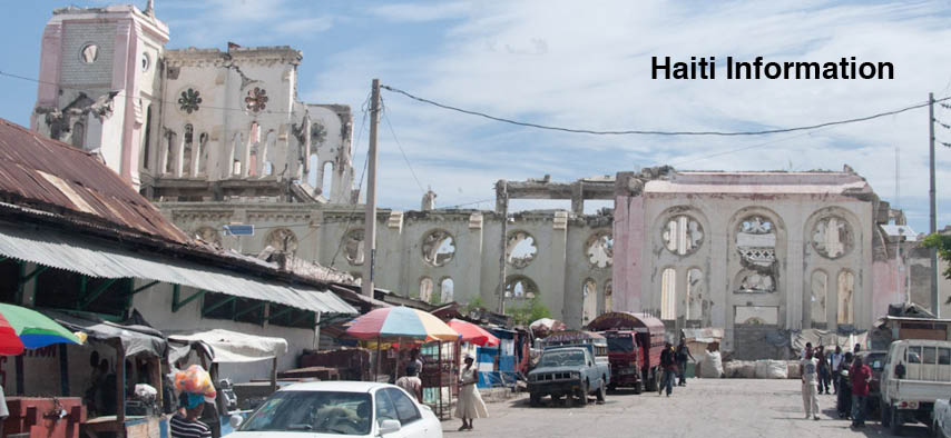
On January 12th 2010, a 7.0 magnitude earthquake struck Haiti, with its epicenter in Léogâne, a town 35 kilometers west of Port-au-Prince. It was the most powerful earthquake in over 200 years causing record numbers of deaths, injuries, and displacements. Water, electric infrastructure, roads, and port systems in the capital and surrounding areas were damaged in the earthquake. Unfortunately not only did the earthquake cause tremendous physical damage, the consequent lack of hygiene and sanitation in the wake of the physical damage post earthquake resulted in the spread of a cholera in various parts of the county in October of 2010. Over 230,000 cases have been reported, and over 4500 deaths. According to USAID this disease will most likely be present in Haiti for over a decade.
Before the earthquake, poverty was endemic in Haiti, with more than half the population living on less than one dollar a day. Most of the destitute individuals live in the rural areas but after the earthquake many men and women made the trip to the capital in search of a better life. Like many other developing nations, the wealth distribution is exceedingly uneven, with the 2001 Household Living Conditions Survey stating the poorest 20% of Haitians have only 2% of the income, while the richest 20% of Haitians have 68% of income in the country.
Given these natural and man-made conditions, the present circumstances in towns and cities in Haiti are challenging and often unhealthy. Some impoverished people still live in tent cities, either in fear that their concrete roofs will collapse, or with nowhere else to go. Open sewers and water drains are blocked and fetid causing the spread of diseases like Malaria, Typhoid, and now the ever-present mosquito-borne virus Chikungunya. Many houses that are still standing show structural instability with missing walls, caved-in roofs and ladders to take individuals to the upper floors. Even buildings previously thought sturdy in the capital are now in ruin, several important cathedrals and the presidential palace among them.
People
The people of Haiti have diverse and mixed ethnic backgrounds including: African, Mulatto (a mixture of European and Africans), Polish, Jewish, Arab, Chinese, Indian, German, Italian, French, and the native population, Taino.
A large majority of the Haitian population today claims African descent; most of these people are of mixed African ancestry. There is also a noticeable white population in Haiti today. These people are descended from French individuals who survived the 1791 Haitian Revolt and 1804 Haitian Massacre and have remained in Haiti.
In the last few decades, there has been an exodus of Haitians to live abroad in countries like the United States, Dominican Republic, Cuba, Canada and France. There are an estimated 881,500 Haitians in the United States. Haitians travel abroad in search of a better life, better education, and better economic prospects.
Presently a majority of the population of Haiti is under 20, with a very low elderly population. The workforce is almost equally divided between the sexes, with 30% of women in the working class, and 35% of men. Unfortunately there is an equal population that is presently unemployed. Like most other developing nations, the infant mortality rate is high due to poor sanitary and living conditions. Following the earthquake, an increase in the unemployment rate resulted in a daily wage of under two dollars for a large majorty of Haitians. These low wages limit the ability for families to provide healthy nourishment and good quality housing for their children.
Housing
Construction materials and methods in Haiti have changed over the last few decades. Newer materials, and techniques have been promoted for economic as well as social benefits, and hence the vernacular fabric of the nation has changed.
Historically, Haitian homes were constructed of timber, as it was plentiful throughout many parts of the country. Good quality timber that was easy to work, combined with knowledgeable craftsman, resulted in aesthetically pleasing homes. In October 2009, the Gingerbread /houses of Haiti were included on the 2010 World Monuments Watch to raise international awareness of this unique architectural heritage. The landscape of cities like Port-au-Prince and Cap-Haitien have changed dramatically from images filled with gingerbread homes in hillside neighborhoods, to a jungle of concrete structures and infrastructure blanketing steep terrain.
Due to the proliferation of concrete, and misconceptions about its easy use and construction, concrete structures are now the norm. This can be seen in three different types of homes in the capital as well as in more rural areas like Petite-Rivière-de-Nippes: 1) multi-story concrete frame with masonry infill and cast in place concrete roof, 2) one story concrete columns with masonry walls and light gauge corrugated metal roof, 3) timber frame with stone infill and a wood framed roof. The town of Petite-Rivière-de-Nippes offers variations in construction because homeowners have built with many readily available materials, often employing traditional building techniques. Materials include woven plant and tree matter covered by natural plaster within timber frame construction, or combinations of infill materials like coral and limestone within a timber or concrete frame.
Climate
Due to its geographical location, Haiti’s climate is mainly tropical, with hot and humid conditions throughout much of the year. Additionally, there are regions in the east along the base of the mountains that support a semi-arid climate, while in the highlands near the border with the Dominican Republic the climate is generally cooler and more temperate. The average temperature is 83°F, average wind speed is 10.6 mph with prevailing wind from East to West, and the average annual rainfall is 54”. Throughout the year there are two intense periods of rainfall during the spring (April-July) and fall (September-November). Periods of drought often follow these rainy seasons. Across the country rainfall is varied, with some of the lowlands and the northern and eastern mountain slopes receiving a great deal of rain while the western coast from the northern peninsula to Port-au-Prince is relatively dry. Hurricanes and flash floods are common, and storm water washes productive top soil away and carries sediment down into the valleys.
Agriculture
Past agricultural practices and current trends in the country have resulted in wide spread deforestation and soil erosion throughout Haiti. Intense export farming on colonial plantations, timber exports, subsistence agriculture, and the necessity for charcoal as a cooking fuel have all contributed to the current state of the environment. Only 20 percent of land is considered suitable for growing crops, yet 50 percent is under production. Most rural subsistence farming in the country takes place on hillsides; farmers grow crops such as beans, maize, cassava, plantain, mango, avocado, and other fruit. Hillside farming contributes to eroded soils and one third of all land is severely degraded. As a result of the steep slope of much of the country’s land (63 percent has a slope greater than 20 percent) and hillside farming practices, a great deal of the topsoil is lost during the each year’s rainy seasons and becomes silt in the river systems. Traditionally, coffee and sugarcane provided the main sources of export revenues for the nation, but in recent years these have been replaced by industrially produced apparel and footwear exports.
The last agricultural survey (1971) found that 59 percent of all agricultural parcels were less than one hectare and 88 percent of all farmers owned less than three hectares. 2001 estimates showed that most peasants own less than a quarter hectare. Sharecropping additional fields is common as individual farmers attempt to increase production. According to a 2001 report by the Food and Agriculture Organization of the United Nations, per capita food production had dropped 20 percent over the previous decade as a result of farming conditions and practices and less expensive imported food arriving in Haiti.
Eric Wayne Ellis
ACSA, Senior Director of Operations & Programs
202-785-2324
eellis@acsa-arch.org
